Search
Malaria is a focal disease and more localized in low endemic areas. The disease is increasingly becoming a concern in urban areas in most sub-Saharan African countries. The growing threats of Anopheles stephensi and insecticide resistance magnify this concern and hamper elimination efforts. It is, therefore, imperative to identify areas, within urban settings, of high-risk of malaria to help better target interventions.
Malaria imposes a significant global health burden and remains a major cause of child mortality in sub-Saharan Africa. In many countries, malaria transmission varies seasonally. The use of seasonally-deployed interventions is expanding, and the effectiveness of these control measures hinges on quantitative and geographically-specific characterisations of malaria seasonality.
Since its inception in 2005, the US President's Malaria Initiative (PMI) has played a major role in the reductions in malaria morbidity and mortality observed across Africa. With the status of PMI funding and operations currently uncertain, we aimed to quantify the impact that a fully functioning PMI would have on malaria cases and deaths in Africa during 2025.
Understanding the geospatial distribution of influenza infection and the risk factors associated with infection clustering can inform targeted preventive interventions. We conducted a geospatial analysis to investigate the spatial patterns and identify drivers of medically attended influenza infection across all age groups in Western Australia.

Children who live in the outer suburbs of Australia’s four biggest cities are twice as likely to have asthma as those living in inner city areas, according to a new study based on health data captured in the last Australian Census.
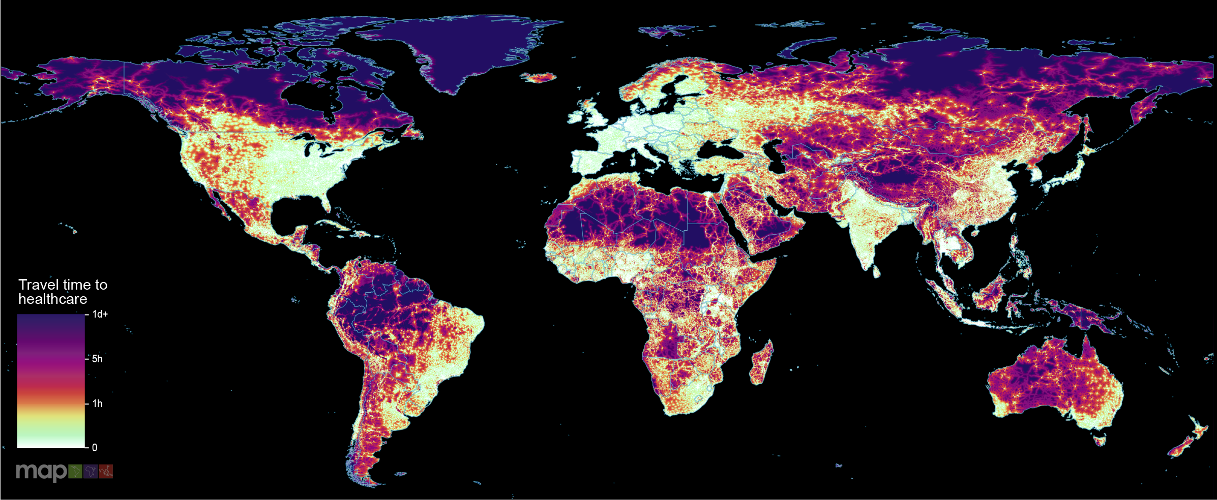
New research which maps the entire global population’s travel time to their nearest healthcare facility has revealed major inequalities in access to healthcare depending on whether people have access to motorised transport or not.
Strongyloidiasis, caused by the soil-transmitted helminth Strongyloides stercoralis, remains a neglected public health issue in Australia, particularly among remote Aboriginal and Torres Strait Islander communities. This study aimed to map the spatial distribution of strongyloidiasis and investigate associated socioecological factors to identify high-risk areas and guide targeted interventions in Australia.
Bacillus Calmette-Guérin (BCG) protects children from severe tuberculosis and remains the only licensed vaccine for tuberculosis. Subnational estimates of BCG coverage are essential for identifying underserved populations across Africa. This study aimed to map BCG vaccination coverage in Africa from 1990 to 2022.
With more than 1.2 million illnesses and 29,000 deaths in sub-Saharan Africa in 2017, typhoid fever continues to be a major public health problem. Effective control of the disease would benefit from an understanding of the subnational geospatial distribution of the disease incidence.
Although most people born this century will be educated in African schools, these schools often lack basic infrastructure, such as electricity and/or lighting. In the face of a rapidly growing school-age population in Africa, the electrification of educational facilities is not just an infrastructural challenge but also a pivotal investment in the continent’s future workforce.