Search
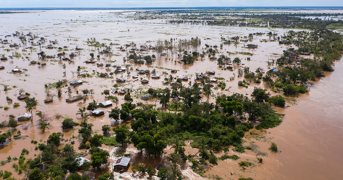
World-first research from The Kids Research Institute Australia and Curtin University predicts climate change could trigger more than 100 million additional malaria cases and 500,000 additional deaths in Africa by 2050, including substantial impacts on children.
Bacillus Calmette-Guérin (BCG) protects children from severe tuberculosis and remains the only licensed vaccine for tuberculosis. Subnational estimates of BCG coverage are essential for identifying underserved populations across Africa. This study aimed to map BCG vaccination coverage in Africa from 1990 to 2022.
Estimating the temporal trends in infectious disease activity is crucial for monitoring disease spread and the impact of interventions. Surveillance indicators routinely collected to monitor these trends are often a composite of multiple pathogens. For example, "influenza-like illness"-routinely monitored as a proxy for influenza infections-is a symptom definition that could be caused by a wide range of pathogens, including multiple subtypes of influenza, SARS-CoV-2, and RSV.
Since their first detection in 2010, Plasmodium falciparum malaria parasites lacking the P. falciparum histidine-rich protein 2 gene (pfhrp2) have been observed in 40 of 47 surveyed countries, as documented by the World Health Organization. These genetic deletions reduce detection by the most widely used rapid diagnostic tests, prompting three countries to switch to alternative diagnostics.
Although most people born this century will be educated in African schools, these schools often lack basic infrastructure, such as electricity and/or lighting. In the face of a rapidly growing school-age population in Africa, the electrification of educational facilities is not just an infrastructural challenge but also a pivotal investment in the continent’s future workforce.
Since its emergence in 1968, influenza A H3N2 has caused yearly epidemics in temperate regions. While infection confers immunity against antigenically similar strains, new antigenically distinct strains that evade existing immunity regularly emerge ('antigenic drift'). Immunity at the individual level is complex, depending on an individual's lifetime infection history.
Tuberculosis (TB) is the leading global cause of death from a single infectious agent. Recent reductions in global health funding have threatened TB control, making comprehensive assessment of TB, HIV-related TB, and drug-resistant TB burdens before these disruptions essential for shaping effective responses.
Detailed, comprehensive, and timely reporting on population health by underlying causes of disability and premature death is crucial to understanding and responding to complex patterns of disease and injury burden over time and across age groups, sexes, and locations. The availability of disease burden estimates can promote evidence-based interventions that enable public health researchers, policy makers, and other professionals to implement strategies that can mitigate diseases.
Future trends in disease burden and drivers of health are of great interest to policy makers and the public at large. This information can be used for policy and long-term health investment, planning, and prioritisation. We have expanded and improved upon previous forecasts produced as part of the Global Burden of Diseases, Injuries, and Risk Factors Study (GBD) and provide a reference forecast (the most likely future), and alternative scenarios assessing disease burden trajectories if selected sets of risk factors were eliminated from current levels by 2050.
Namibia, a low malaria transmission country targeting elimination, has made substantial progress in reducing malaria burden through improved case management, widespread indoor residual spraying and distribution of insecticidal nets. The country's diverse landscape includes regions with varying population densities and geographical niches, with the north of the country prone to periodic outbreaks.